Sonoma Ag + Open Space District Map Templates
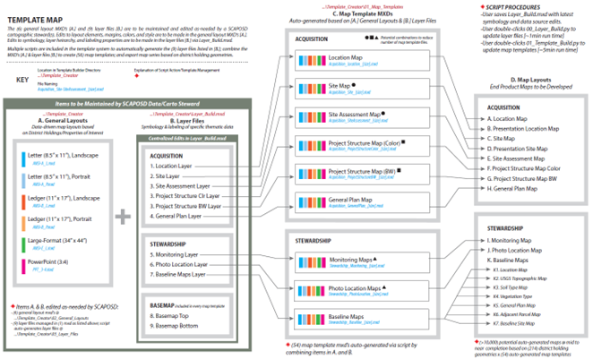
The Sonoma County Agricultural Preservation and Open Space District (SCAPOSD) engaged DP+S to modernize its land stewardship data workflows and create a unified, District-wide system for GIS mapping, reporting, and field data management. The District manages thousands of acres of protected lands, and its staff needed a streamlined, accurate, and repeatable process to track stewardship […]
Shasta Lake Housing Element

Dynamic Planning + Science partnered with the City of Shasta Lake to develop its 6th Cycle Housing Element as part of the City’s broader 2040 General Plan update. The Housing Element serves as the City’s strategic plan to address the housing needs of current and future residents across all income levels, with a focus on […]
Montrose County MJHMP

Dynamic Planning + Science led the 2018 update of Montrose County’s Multi-Jurisdictional Hazard Mitigation Plan (MJHMP), supporting county agencies, fire protection districts, and municipalities in identifying strategies to reduce risk from natural hazards. This comprehensive update integrated modern geospatial analysis and robust public engagement to strengthen the region’s resilience across a broad, rural area encompassing […]
San Bernardino City Unified School District HMP

Dynamic Planning + Science partnered with SBCUSD to develop its first FEMA-approved Hazard Mitigation Plan (HMP), focused exclusively on reducing risks to District facilities and protecting over 53,000 students and staff. The HMP outlines strategies to mitigate the impacts of natural hazards such as wildfires, flooding, drought, extreme heat, and seismic activity across a 160-square-mile […]
City of McFarland HMP

Dynamic Planning + Science partnered with the City of McFarland to complete a comprehensive update of its Local Hazard Mitigation Plan (HMP), building on the 2015 plan and reinforcing the city’s commitment to reducing long-term risks from natural hazards. The 2023 HMP meets FEMA and DMA 2000 requirements and maintains the city’s eligibility for key […]
City of Tehama General Plan Update

Dynamic Planning + Science led a comprehensive technical update of the City of Tehama’s General Plan, guiding long-term growth and land use decisions through the year 2045. As the city’s foundational planning document—often referred to as a “constitution” for future development—the General Plan outlines goals, policies, and implementation actions across six state-mandated elements: Land Use, […]
City of Napa HMP

Plan Update and Feasibility Study: Updated Tehama County’s 2012 Hazard Mitigation Plan and developed a Community Rating System program feasibility study to enhance flood resilience.
Flood Inundation Mapping: Created detailed flood and dam inundation mapping products for high-risk areas to support emergency response and public awareness.
Public Outreach Materials: Developed engaging maps to communicate anticipated flood depths along the Sacramento River Corridor, focusing on vulnerable populations.
Funding Alignment: Identified practical mitigation actions and funding opportunities, ensuring alignment with FEMA grant guidelines.
Proven Expertise: Built on a successful track record of securing grants and collaborating with local and state agencies for mitigation projects.
Lancaster School District CEQA Compliance Services

Plan Update and Feasibility Study: Updated Tehama County’s 2012 Hazard Mitigation Plan and developed a Community Rating System program feasibility study to enhance flood resilience.
Flood Inundation Mapping: Created detailed flood and dam inundation mapping products for high-risk areas to support emergency response and public awareness.
Public Outreach Materials: Developed engaging maps to communicate anticipated flood depths along the Sacramento River Corridor, focusing on vulnerable populations.
Funding Alignment: Identified practical mitigation actions and funding opportunities, ensuring alignment with FEMA grant guidelines.
Proven Expertise: Built on a successful track record of securing grants and collaborating with local and state agencies for mitigation projects.
Arvada Soccer Association Entitlements

Plan Update and Feasibility Study: Updated Tehama County’s 2012 Hazard Mitigation Plan and developed a Community Rating System program feasibility study to enhance flood resilience.
Flood Inundation Mapping: Created detailed flood and dam inundation mapping products for high-risk areas to support emergency response and public awareness.
Public Outreach Materials: Developed engaging maps to communicate anticipated flood depths along the Sacramento River Corridor, focusing on vulnerable populations.
Funding Alignment: Identified practical mitigation actions and funding opportunities, ensuring alignment with FEMA grant guidelines.
Proven Expertise: Built on a successful track record of securing grants and collaborating with local and state agencies for mitigation projects.
City of Delta Planning Services

2019-Ongoing DP+S has provided planning services to the City of Delta since 2019, including development review, floodplain management, and long-range planning support. This role has primarily been filled by DP+S staff member Raini Ott since May 2021, with occasional support from other team members. In our time working with the city, we have become intimately […]